| Kanawha
River
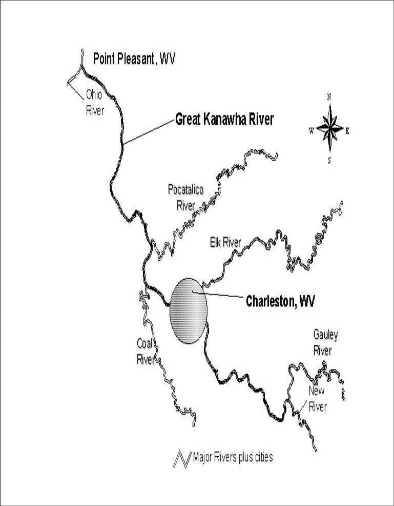
The Kanawha River is West Virginia’s largest inland waterway. Most history
books and maps refer to it as the "Great Kanawha River". It
is formed at the town of Gauley Bridge in northwestern Fayette County,
approximately 35 mi SE of Charleston, by the confluence of the New and
Gauley rivers. Mountain river drainage from North Carolina fills the New
River, to the Gauley River then to the mouth of the Kanawha at Kanawha
Falls.
It flows generally northwest, in a winding course through Fayette, Kanawha,
Putnam and Mason Counties, past the cities of Montgomery, Charleston and
St. Albans and numerous smaller communities. The Great Kanawha flows for
43 miles in Kanawha County. The Kanawha enters the Ohio River at Point
Pleasant in Mason County, 99.5 miles west of the confluence of the New
and Gauley River. (View
Map)
The Name
The Kanawha River (pronounced kuh-NAW or less often ka-NA-wah and earlier,
kuh-NOIE), was named for the Indian tribe that once lived in the area.
The spelling of the Indian tribe varied at the time from Conoys to Conois
to Kanawha. The latter spelling was used and had gained acceptance over
time. In 1744, the Seneca boasted to Virginia officials that they had
conquered the several nations living on the back of the great mountains
of Virginia. Among the conquered nations were the last of the Canawese
or Conoy people who became incorporated into some of the Iroquois communities
in New York. The Conoy continue to be remembered today through the naming
of two of West Virginia's largest rivers after them, the Little Kanawha
and the Great Kanawha.
The Great
Kanhaway
Most Native America tribes seem to have indentified the New River and
the Kanawha River as being one river, as did many early white explorers.
Thomas Jefferson regarded the New and Kanawha Rivers as a single river,
referring to it as "the Great Kanhaway" in his Notes on the
State of Virginia, written in 1781, revised in 1782, in which he described
the river as follows:
"The Great Kanhaway is a river of considerable note for the fertility
of its lands, and still more, as leading towards the headwaters of James
River. Nevertheless, it is doubtful whether it’s great and numerous rapids
will admit a navigation, but at an expense to which it will require ages
to render its inhabitants equal. The great obstacles begin at what are
called the great falls, 90 miles above the mouth, below which are only
five or six rapids, and these passable, with some difficulty, even at
low water. From the falls to the mouth of Greenbriar is 100 miles and
thence to the lead mines 120. It is 280 yards wide at its mouth."
Navigation
In 1819, the steamboat Robert Thompson ascended the Kanawha River for
the purpose of ascertaining whether it was navigational to Charleston.
The voyage continued as far as Red House Shoals , in present-day Putnam
County, where two days were spent in a vain effort to pass the rapids,
and the boat returned to the Ohio; the officers reported to the Virginia
Assembly the result of the experimental voyage, and that body in 1820,
made the first appropriation for the improvement of the river. In 1820,
the Albert Donnally, built for salt manufacturers on located along the
Kanawha Saltines, ascended to Charleston and the traffic by river thereafter
steadily increased.
The failure of the steamer Robert Thompson to ascend the river, and the
success of the Andrew Donnally in reaching Charleston the following year,
were events of so much importance, that the General Assembly of Virginia,
at its next session in 1820-1821 provided for the improvement of the river,
so that three feet of water could be secured all the year to the Kanawha
Falls. Surveys were made and the work on a series of sluices and wing
dams began at Red House Shoals, and at the mouth of Elk River, in 1825,
under the direction of John Bosser, but these solutions were not sufficient.
Large shipments of coal after 1855 result in urgent demands for better
navigation facilities. In 1860 steps were taken to extend the old sluice
and wing dam system, but they were suspended by the Civil War. Packets
between Charleston and Gallipolis, which at first ran weekly and later
triweekly, began in 1845 a daily service which continued until after the
Civil War.
Following the creation of West Virginia in 1863, the State took charge
of the Kanawha River and created a Kanawha board to carry on this improvement
and collect tolls as the James River and Kanawha Company had been doing.
It was not until 1870 that work was begun on a regular system of locks
and dams until action of Congress.
Ten Chanoine dams on the Kanawha River were completed in 1898, to provide
for year-round water transportation on the Kanawha River from Boomer to
Point Pleasant, a distance of 90 miles. This system was replaced in the
early-1930s by the U.S. Army Corps of Engineers with four high lift dams
with German roller gates. The system at Gallipolis was built on the Ohio
River and Winfield, Marmet and London were built on the Kanawha. Starting
in 1989, improvements were made to three of these locks and dams with
the addition of lock chambers. The river is now navigable to Deepwater,
an unincorporated community above Montgomery, WV and about 20 miles upriver
from Charleston. Thriving chemical and coal industries along its banks
provides a significant part of the local economy.
Tributaries of the Kanawha River
The Elk River
The Elk River is the main tributary of the Kanawha River. The Elk flows
for 180 miles from its headwaters in Pocahontas County to its mouth in
Charleston. The Elk River has been called many names, such as, "Tiskelwah",
an Indian name, which means river of fat elk, Miami Indians called it
the "Pequonicepe", the Delaware Indians called it "Toquemincepe"
which means Walnut River. The Elk River was used for transportation of
timber by the timber companies. Timber products were sent down river from
the north to the Charleston mills. In the 1930’s houseboats were common
on the Elk.
Coal River
The Coal River flows north from its headwaters in Boone County to its
mouth at St Albans, a distance of 59 miles, 28 of these miles are in Kanawha
County.
Pocatalico River
Pocatalico is an Indian name that means "the river of the fat doe"
• Campbells Creek
• Kelly's Creek
• Paint Creek
• Kanawha Two Mile
• Cabin Creek
• Hughes Creek
• Smithers Creek
Cities
and Towns Along the Kanawha River
• Bancroft
• Belle
• Buffalo
• Cedar Grove
• Charleston
• Chesapeake
• Dunbar
• East Bank
• Eleanor
• Gauley Bridge
• Glasgow
• Handley
• Henderson
• Jefferson
• Leon
• Marmet
• Montgomery
• Nitro
• Poca
• Point Pleasant
• Pratt
• St. Albans
• Smithers
• South Charleston
• Winfield
|


